By Laura Nowlin
Through the vast spaces of central Montana flows the Musselshell River, connecting the mountains to the breaks and Martinsdale to the Missouri River. To the casual observer it looks like a lazy, quiet stream, and the land around it like stolid timber and whispering grass, but those who live along it know better.
Roundup flooding in 2001 (Photo by Chris Boyer, Kestrel Aerial / Musselshell Watershed Coalition.)
Since 2011, the region has been plagued with one disaster after another– floods in 2011, 2013, and 2014, and fires in 2012 and 2017. But the people here are strong. They persevere, and with each disaster, they become more resilient. The Musselshell cannot claim strength in numbers (only 9,500 people live in the entire 6-million-acre watershed), but it can claim strength in neighbors.
“Don’t doubt for a minute that neighbor is a verb out in these parts!”
This phrase, first heard during the relief efforts following the Lodgepole Complex fires, truly captures the hard-working nature of the residents of the Musselshell Watershed, and their commitment to each other and to their communities.
Landowner and Petroleum County Conservation District Supervisor Diane Ahlgren (in pink), shows Donna Pedrazzi, landowner and Lower Musselshell Conservation District administrator the path of the Lodgepole Complex fires. Musselshell Watershed Big Sky Corps members John Lange and Willie Friedman (far left) look on. (Photo by Eliza Wiley)
When the flood waters of 2011 began to rise, Teri Hice, the seasoned water manager for the Deadman’s Basin Water Users Association, knew that this would be a flood event like none she had seen. She began calling and texting those further downstream to get animals, equipment, and other property away from the ever-rising wall of water. Others followed suit and a chain of notifications saved an untold amount of property from being lost in what has been estimated as a flood of anywhere from 150-year to 500-year proportions.
Still, more than 300 people found themselves stranded when County Road 4 near Roundup flooded. For two weeks, these people relied on their neighbors to bring them necessities – prescriptions, food, drinking water, all of which was delivered by boat. When the flood waters receded, damage incurred by the county governments totaled more than $6.5 million, and when the shock wore off, the work began.
Musselshell County immediately decided to focus on a stretch of river through the city of Roundup, including County Road 4.
“It is a significant safety problem that we have to get fixed,” said County Road Supervisor Tom Stockert at a planning meeting held by the Musselshell Watershed Coalition. The county also embarked on an ambitious project to remove repeatedly flooded properties from the floodplain and create community recreation spaces in their place.
The city of Roundup and Musselshell County approached the Montana Department of Natural Resources and Conservation Floodplain Bureau about updating the community’s floodplain maps. This effort spurred a river-long floodplain mapping project with the DNRC for each town along the Musselshell River and several other areas of local concern.
Roundup Mayor Sandra Jones (Photo by Eliza Wiley)
“We are working to be more resilient,” said Roundup Mayor Sandra Jones. “It is going to flood again. It’s not if, but when, and next time we will be better prepared and our community will be more resilient in the face of it.”
The 2011 flood also resulted in 34 channel cut-offs that made the river 10 percent shorter than it had been – resulting in a faster and steeper river. Because of this, dams were flanked, channels were abandoned, and pump sites were wiped out. Landowners and water users had tough decisions to make. Said one landowner, “Let’s figure out where this river wants to be before we get all permanent and expensive.” The Deadman’s Basin Water Users Association decided to launch a $1 million replacement and repair project for its diversion dam and headgates. Completed in 2016, the project boasts a cutting-edge fish passage, whose design passes the northern red bellydace, a species of concern in the Musselshell.
Newly completed Deadman’s Diversion and fish passage in 2016. (Photo by Laura Nowlin / Musselshell Watershed Coalition)
The Kilby Butte Ranch suffered an avulsion that cut through a hay field and isolated more than 15 acres from access for haying. Their decision meant plugging the avulsion or leaving it alone. Ultimately, the ranch decided to allow the river to run its course. Similarly, ranchers Jim and Ross Ballard and Trent Wallis collaborated with Montana Fish, Wildlife, and Parks to remove a dam that had been on the river for decades. That structure, the Egge Dam, was flanked during the 2011 flood and was no longer useful.
Rancher Ross Ballard near the site of the recently removed Egge Dam (Photo by Eliza Wiley)
The dam removal project was finished in 2017, and its absence opened up many miles of the Musselshell River. Downstream, FWP has just finished an analysis of fish passage at another dam site where owners Jim and Donna Pedrazzi are interested in supporting fish passage, as well as alleviating upstream flood issues exacerbated by the dam on their place. Each of these landowners and irrigators have carefully thought through the effects of their decisions on their neighbors.
In order to better assist landowners like the Ballards, Stahls, Pedrazzis and other locals affected by the flood, the Musselshell Watershed Coalition (MWC) partnered with state and federal agencies to form a River Assessment Triage Team to work with landowners to assess their issues and determine best management practices for future resiliency. The MWC also worked with other stakeholders along the river to complete a Musselshell Watershed Plan – a working document that prioritizes projects along the river.
Rancher Joe Stahl, describes the 2011 flood impacts during MWCC’s watershed project tour in the Musselshell.
During this process six public meetings were held. Participants of those meeting expressed their own needs, while also expressing concern over how their actions might affect the river and their neighbors downstream. Channel migration zone mapping emerged as one of the prioritized projects for the Musselshell River. As a result, MWC is currently working to have channel migration zone mapping completed for the entire river. These maps will help determine where the river might go and how changes in one place might affect another. Importantly, it is a map that will chart a course for continued collaboration along the Musselshell, to the benefit of both river and community health.
Donna Pedrazzi, owner of the Newton Dam, and Mike Ruggles, fisheries biologist for Fish, Wildlife, and Parks, look over the site being discussed for fish passage. (Photo by Eliza Wiley)
From 2012 to 2016, neighbors on the Musselshell River again and again responded to each other’s needs during times of disaster. Fires bad enough to warrant presidential disaster declarations in 2012, flooding in 2013 and again in 2014. Lessons learned were applied the next time around – and in-between, people worked to recover and be more prepared for future problems. Their spirit was once again tested during the 2017 summer of wildfires.
View of a portion of the area burned by the 2017 Lodgepole Complex fires. (Photo by Eliza Wiley)
“The ranch can be rebuilt, but knowing who will be there for you when things get tough, that is irreplaceable,” said Mary Brown, a landowner near Sand Springs.
Local volunteer fire departments held the line when the fires first started, extinguishing eight of the 12 fires that started that night. The other four fires continued to burn and neighbors arrived to help.
“When you look at a community, people just kept rolling in from all over. People are so generous, it’s unreal,” said Gary Eliasson, a landowner near Roundup and lessee near Sand Springs. They came to help save animals, buildings, equipment, crops, and to fight the fire – and they came to every reach of the 270,000 acres that burned.
Upstream, the water users of the Deadman’s Basin Water Users Association, also in severe drought, made a tough decision. The water manager and the Chief Water Commissioner for the Musselshell Distribution Project, decided to let stored irrigation water from Deadman’s Basin Reservoir flow downstream so it could aid in the firefighting efforts. It doesn’t get any bigger than sacrificing water for your neighbor in times of drought.
Dean Rogge, local rancher. (Photo by Eliza Wiley)
Gary Eliasson has survived the 2011 flood, the 2012 fires, the 2014 flood, a freak spring blizzard that killed livestock in 2016, and now the 2017 fires.
“I know that people say that we’re being tested to see how strong we are, but …” he reflected, trailing off before finishing the thought.
How tough are the people of the Musselshell? Pretty darn. But, one thing they’ve learned is that no matter how tough you are, you can’t go it alone. Dean Rogge, landowner and conservation district supervisor said about the fires, “It’s the people I worry about losing – they are the most important.”
Dean, Daine Ahlgren, and several others are involved in the Musselshell Watershed Coalition as well as the Charles M. Russell Community Working Group and other organizations that foster collaborative approaches to community sustainability.
Reba Ahlgren of the Winnett Natural Resources and Conservation Service office explains the programs offered by the NRCS for fire recovery. Laura Nowlin, coordinator for the Musselshell Watershed Coalition, listens during the MWCC 2017 Water Tour. (Photo by Eliza Wiley)
“Each time you have a disaster, there are more partners and we get better,” Dean said of recovery after the fire. Key local, state, and federal partners of landowners in the Musselshell watershed work together to reach the same goals – and support each other in times of need. Within one week of the fires being extinguished, the Charles M. Russell Wildlife Refuge opened grazing leases to those affected by the fire, the DNRC secured $75,000 for fire recovery, and the Musselshell Watershed Coalition worked with the Montana Conservation Corps to get a free fencing crew. These partnerships build off from the attitudes of the landowners and from their care and connection to the land.
“It’s going to be beneficial, it’s going to take some time, but we’ll get there,” said Diane Ahlgren, a landowner, following the fire.
Photo by Shelby Browning
This crazy, wonderful river binds together the people that live and work along it. Their perseverance and strength builds stronger communities. Their roots, deep and strong, and their faith unwavering in the river’s ability to provide.
Laura Nowlin is the coordinator for the Musselshell Watershed Coalition and serves on the board of the Montana Watershed Coordination Council. She lives on the family ranch with her husband and two children north of Winnett on a tributary to the Musselshell River.
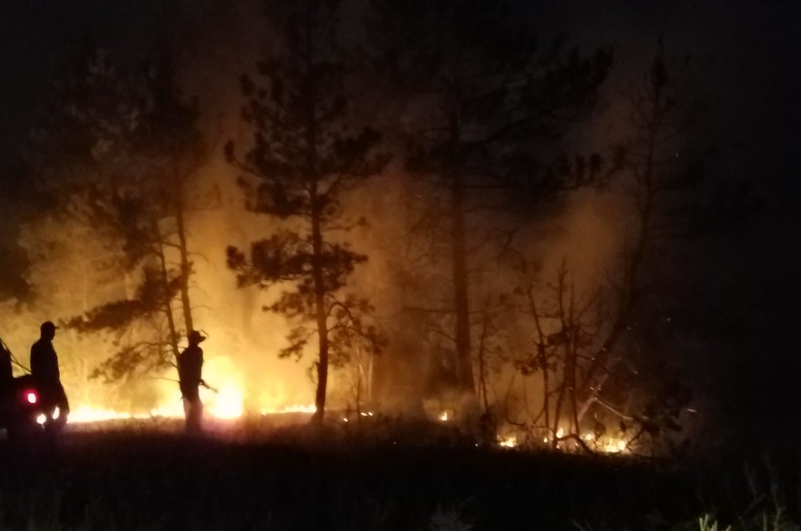
Cover photo: Jim Brady and Skip Ahlgren, local ranchers, fight fire near the Ahlgren place during the Lodgepole Complex burn. (Photo by Brenda Brady)
All photos courtesy the Montana Watershed Coordination Council.
Got something to say to Prairie Populist? Send news tips, story ideas and comments to [email protected]. If you have something to submit, or an idea for a story you’d like to write for us, check out our Submission Guidelines here.